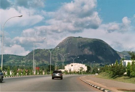
The contemporary and historical Aso Rock
As the highest geographical point of the Federal Capital City, and the most imposing figure visible from any part of the city, the Aso Rock was used as the reference point while drawing the first concept plan for the development of the city by the International Planning Associates (IPA), while producing the Abuja Master Plan. […]

As the highest geographical point of the Federal Capital City, and the most imposing figure visible from any part of the city, the Aso Rock was used as the reference point while drawing the first concept plan for the development of the city by the International Planning Associates (IPA), while producing the Abuja Master Plan. The area around the Aso Rock was the meeting point of the two major expressways serving as the outermost limits of the city’s development.
The city as was conceived, assumed a crescent shape, radiating from the AYA to the North Western direction along the Outer Northern Expressway (ONEX), flanked by the Zuma-Bwari-Aso mountain ranges, and to the other direction at ninety-degree angle radiating to the South-West along the Outer Southern Expressway (OSEX), flanked by the Kanu-Agwai and the Zongon-Kuku hills.
The Aso Rock derived its name from the name of the original community inhabiting the area surrounding it. These were the Gwandara tribe of Aso. The peace-loving community were resettled in Sabon Wuse, Niger State since 1980. The Seat of Government of the country was named the Aso Villa Chamber. Perhaps, due to its close proximity with the rock, or, as a symbol of might, being the most dominant singular and massive granitic structure, visible from all parts of the Gwagwa plains, where the Capital City situated.
Historically, prior to the colonial era, the Aso people were said to have migrated from the ancient Kano Kingdom, and settled at Likoro, before their final settlement at Kurmin Aso, close to the foot of the mountain. From their first Chief, named Dodoniya, they had up to 13 chiefs to the one presently reigning at Sabon Wuse, Malam Ibrahim Ango, who was enthroned in February 2002. Prior to the creation of the FCT in 1976, the Aso community was at the eastern boundary of the former Abuja Emirate of Niger State, and shared boundary with Karu/Nyanya in the Keffi Emirate of the former Plateau State. The other communities surrounding Aso were the Kpaduma (Kurunduma), Garki and Wuse. The villages under the Aso chiefdom were Dankpara, Katuka, Shishipe, Jika-Kuchi, Juwu-Kuchi and Gudu-Pedna.
Beyond the contemporary recognition on the advent of the FCT at Abuja, the Aso people had an historical attachment to the Aso Rock. According to the historical and mystical narrative, a long time ago, one of their married women was unjustly treated, and upon a disagreement with her husband she fled to the location at the foot of the monumental Aso Rock and disappeared. They then developed the belief that she got transformed to a particular rock. As a result of which the community started paying homage and making offerings to the smaller rock at the foot of the Aso Rock, seeking divine intervention.
In the olden days, the foot of the Rock was a habitat for wild animals, like lions and hyenas. The Aso people also used to conduct some traditional rights and celebrations under the Rock for seven days in their quest for rain anytime there was famine, and according to such mystical belief, their requests were answered. Also, anytime there was a threat of enemies’ invasion, what the enemies would see was a big ditch as they approached the Aso community and it would be impossible to get attacked. Anytime there was an impending calamity, they made offerings at the foot of the Rock to avert it. They also had the mystical belief that any time there was a wild fire on top of the Rock, it was an advance notice heralding the death of a very prominent ruler. All these mystical beliefs were abrogated upon the Islamisation of the community. However, when the traditional ruler Danladi Ango, turbaned 63 of his subjects with various titles two weeks ago, there were celebrations and coincidentally it rained heavily that night, despite being in late November. I was not surprised that the mystical belief got rejuvenated by the locals.
The original inhabitants of the FCT affected by the city development were given options of resettlement either within or outside the FCT. Unlike their erstwhile Gbagyi neighbours, in Karu, who were divided, with some remaining behind and some resettled in the former Plateau State, the Aso community and many of their other neighbours of Niger State origin, chose to be wholly resettled.
They may have lost their original and ancestral land in the course of sacrificing for the smooth development of the new Federal Capital City, but their identity as “Aso” people gained them a permanent and indelible recognition in the annals of the nation by the “Aso Rock” not only becoming the corner stone of planning for the development of the new Federal Capital city, but also and most importantly, the name “Aso Rock Villa” as the name of the official residence and Office of the President of the Federal Republic of Nigeria.
